Kedaka River
|
About:
|
.jfif)
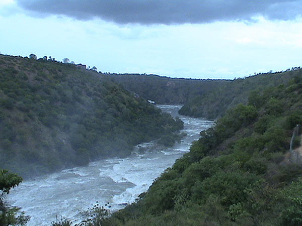
The Kedaka River is a serene waterway located in the heart of the Western Ghats in Karnataka, India. This small but significant river flows through dense forests, fertile fields, and hilly terrain, providing sustenance and beauty to the surrounding regions. Known for its pristine waters and tranquil surroundings, the Kedaka River remains largely untouched by urbanization, making it a favorite spot for nature lovers and those seeking solitude in nature. The river, rich in biodiversity, supports a variety of flora and fauna unique to the Western Ghats, including many species of fish, birds, and reptiles. Local communities, reliant on its waters for agriculture and daily needs, consider the Kedaka River sacred, and local legends often tell of the river’s origins tied to ancient deities. While relatively unknown compared to larger rivers in Karnataka, the Kedaka offers picturesque views, peaceful trails, and a glimpse into the traditional lifestyles of the people who live along its banks. Its seasonal flow, especially robust during monsoon, makes it a lovely destination for short treks, picnics, and experiencing the natural beauty of Karnataka.
|
Location info:
|
| Address:The Kedaka River is a river flowing through Kundapur and Gungulli
in western India. |
| District:Udupi district |
| Nearest City:Kundapura |
| Region Western Ghats, Karnataka, India. |
Climate/Weather:
|
| Monsoon: Heavy rainfall from June to September, bringing the river to full flow and filling surrounding greenery.
Summer: Warm, ranging from 25°C to 35°C, with a drop in water levels.
Winter: Cool and pleasant, with temperatures between 15°C to 25°C, making it ideal for visits. |
History:
|
| The Kedaka River has a history deeply intertwined with the lives of local villagers and the ecology of the Western Ghats. Traditionally, the river has served as a primary water source for nearby agricultural activities, sustaining crops such as paddy, areca nut, and spices like cardamom. The river's origins are celebrated in local folklore, with legends speaking of a divine connection, where deities are believed to have blessed the river for the prosperity of the region. Over centuries, the river has witnessed both the ebb and flow of civilizations and natural cycles, with its biodiversity and cultural relevance persisting as a testament to the harmonious relationship between the river and the local communities. In recent decades, conservation efforts have been initiated to preserve the Kedaka River and its ecosystem, recognizing its importance in maintaining the delicate balance of the Western Ghats’ flora and fauna. Although development pressures exist, the Kedaka River remains largely pristine, reflecting the traditional lifestyle of people who continue to protect and revere it. This historical bond between nature and humanity endows Kedaka with a unique charm, adding to its attraction as an unspoiled natural destination in Karnataka.
|
Interesting things to do:
|
| Nature Walks: Explore the trails along the riverbanks surrounded by thick forests.
Photography: Capture scenic landscapes, especially during the lush monsoon season.
Bird Watching: Spot various species of birds native to the Western Ghats.
Picnicking: Enjoy a quiet picnic by the riverbank, soaking in the peaceful atmosphere.
Trekking: Hike through the nearby hills for an immersive experience of the area’s biodiversity. |
Interesting things to Visit:
|
| ☀ Kundeswara temple is within the town, with big arches. Kundapura town is
surrounded on three sides by water / back water - and as such one can find good
scenes of water and coconut trees all around. The boat point to Gangolli is one
such beautiful place, with vast area of back waters of Haladi river, which joins
Arabian Sea nearby. From this point, the range of Western Ghats at a distance of
20 km, including highest peak Kodachadri is a beautiful sight. The three-sides-
water- town concept of Kundapur is not exploited to develop tourism industry in
this area. There are good number of lodges in this town and well connected by
Highway to Mumbai, it has good potential to develop as a scenic place.
☀ Sri Vinayaka (Ganesh) Temple at Anegudde, between Kota and Koteshwar
towns. (5 k.m. from Kundapura) The area where the temple stands is called
Kumbhashi. Among the several temples in Kumbhashi Anegudde, Sri Vinayaka
Temple is the oldest, and it is also the most popular in this region. This
Ganesh temple is on a small hillock, giving the name Anegudde, "Ane" meaning
elephant and "Gudde" meaning a hillock (in kannada).
☀ Mekekattu Nadhikeshwara temple is interesting place, about 20
k.m.from Kundapura. It is nearer to Barkuru chowlikere temple. It is
considered as the creation of sage Parashurama. With the passage of time the
area where the temple is situated has been called by different names.
According to the legends, when drought hit this area sage Agastya came here
to perform Yajna to please the rain god. During the Yajna, the Asura Kumbha
started bothering the sages. To rescue the sages Bhima killed the demon with
the help of the sword gifted by lord Ganesha. It attracts several thousand
visitors every year. Striking feature of Mekkekattu temple is a collection
of coloured, wooden idols which measure up to 10 feet height! Most of the
wooden statues are in warrior dress, giving an impression that this entire
row of wooden statues are made to remember an incidence of war that would
have taken place here during 1600-1700 AD (no historic evidence for this war
is found yet, but can be linked to Mogul / Bahamani Invasion). Some of the
statues are like Muslim soldires, some like maratha soldies. Some even hold
a replica of old gun, some carry swords and ready for war. All wooden
statues are given local mytholigical name and there are tiger, crow, moneky
also in the row. Yettinahatti, very near to Mekke kattu is interesting place
where bulls are worshiped, and may have some historical links with Mekke
Kattu.
☀ Basrur - Many temples are located here on the southern banks of the
river Varahi. History says Basrur is main and center place of Kundapura
Taluk and it has several historical structures.
☀ Uppinakudru - Uppinakudru or salt island is located at 6Km towards
north of Kundapura which is a taluk headquarters in Udupi District
(Karnataka , India) .
|
Mobile range info:
|
| Network coverage varies, with limited connectivity in dense forest areas along the Kedaka River. BSNL generally offers the most reliable coverage in rural areas. It is advised to confirm coverage and keep emergency contact details before traveling.
|
How to reach?
|
| Nearest Railway Station:Kundapur is also connected by Konkan Railway
which runs through Mumbai, Mangalore. Kundapur Railway station is about 4 km
from town. |
| Nearest Airport:The nearest air port is Mangalore Situated around 100 km
from kundapur. |
| Road Transport:Kundapur is well connected by Road to Parts of the
country. There are buses to Kundapura from Udupi - the bus service is very hot
and moving. One can also see Saligrama, Brahmavara while going to Kundapura from
Udupi. |
Nearest Visiting places:
|
| ☀ Gangolli,even though very near to Kundapura, one has to travel more than
15 km to reach this place as Panchagangavali river separates this from Kundapura
town. One can also take boat ride, which depends on High tide timings! This is a
beautiful place located at bank of 5 rivers and Arabian sea. Fishing is main
activity. Veereshwara Temple is one of the oldest temple of Gangolli.
☀ Maranakatte This is a place located at a distance of about 18km from
Kundapura and known for its Temple of "SRI BRAMHALINGESHWARA", which is
located in the bank of river Souparnika. It has a mythological connection
with the Kollur "MOOKAMBIKA" temple, this being the place where the Goddess
of Kollur killed Mookasura, the Rakshasa(Demon).
☀ Halady a village at a distance of 22 k.m. from Kundapura town is
known mainly as a junction of roads leading to Shankaranarayana, Amasebail
and Hebri. An old Tiles factory was busy burning red tiles during 1980s in
Halady, but this industry has become obsolete and outdated because of
dwindling forest cover, from where the logs were supplied to bake tiles. The
Halady River or Varahi River is flowing besides this village. Marlu chicku
is one deity of Halady which attracts large number of people from far off
places, and another temple is of Laxmi Narasimha with 7 feet stone statue.
The river in front of this temple is beautiful scene.
☀ Vakwadi This is a small village located between Anegudde and
Huvinakere and about 2 k.m. from Koteswara. A temple of Mahalingeshwara
about 2 km from Anegudde is there to serve.
☀ Bidkalkattethis is a small village near halady.this place is between
molahalli and hunsemakki. it has govt.high college & hospital.
☀ Molahallithis is a small village near bidkalkatte.it is a birth place
of 'sahakari pithamaha' M.Shivarao.shivaraya temple located in this
place.'KAMBALA'of molahalli is famous in k'pura taluk.
|
Nearest Petrol Pump:
|
| Petrol pumps are available in Agumbe (around 15 km) and Thirthahalli (about 35 km away).
|
Hotels/Lodge/Accommodation:
|
| Agumbe: Offers homestays and budget lodges with local hospitality.
Thirthahalli: A town nearby with more options including hotels and guesthouses.
Homestays: There are eco-friendly homestays in nearby villages that provide a local experience. |
Things to carry:
|
| Comfortable clothing and durable footwear, especially for trekking.
Rain protection (umbrella or raincoat) if visiting during monsoon.
Drinking water, snacks, and insect repellent.
Camera and binoculars for birdwatching and scenic photography.
First-aid kit and personal essentials. |
Tips & Suggestions:
|
| Visit during or after monsoon for the best views of the river at full flow.
Exercise caution on trails, as they may be slippery during the rainy season.
Respect local customs, as the river is considered sacred by the communities.
Carry sufficient cash, as ATM facilities may not be readily available nearby.
Minimize environmental impact by avoiding littering and following eco-friendly practices. |
Help Line/Phone Number:
|
| Police Station:Kundapur |
| Nearest Hospital:Kundapur |


